Soils of 50 ha CTFS LTER plot
and upper catchment of Conrad Creek
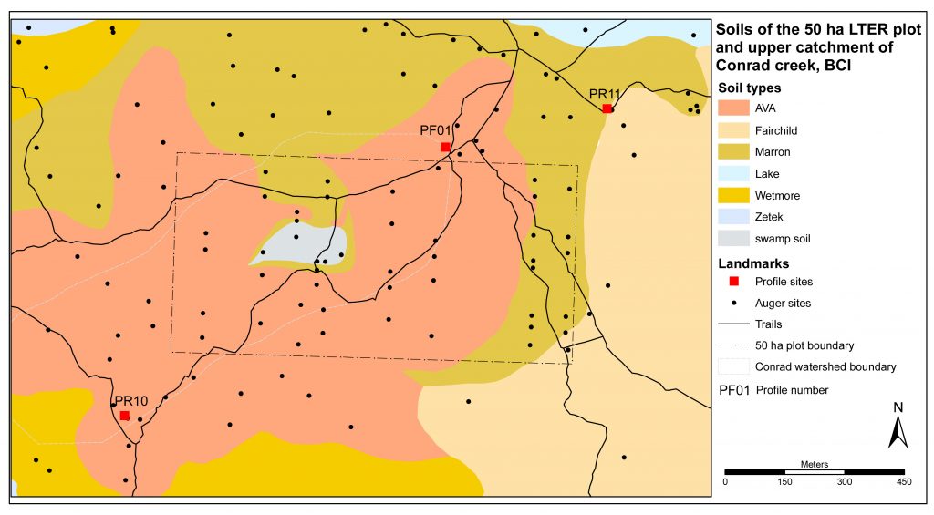
The 50 ha LTER plot was sited so as to minimise abiotic environmental variation (Harms, 2001). It is located in the centre of the andesite dipslope, and is as topographically and geologically homogeneous as is possible for an area of 1 x 0.5 km on BCI. The plot covers most of the upper catchment of Conrad Creek, which was the kaolinite watershed in the geo-hydro-chemical study of Johnsson & Stallard (1989).
Most of plot is flat or gently sloping, with minor scarp slopes along the eastern boundary and even slighter slopes in the northwestern corner. The principal interruption to the main surface is the shallow valley of upper Conrad Creek and its swamp in the centre of the plateau.
Because the plot is kept as inviolate as possible, we examined the soils only in augerings and took no samples. We characterised and sampled the soils in more detail in profile pits just outside the plot border (Figure 7.1). In a separate study, topsoils have been sampled at 300 points within the plot and analysed for Mehlich-extractable nutrients (John et al., 2007).
Soil variation is limited, with Ava red light clays covering 72% of the plot. They typical Ava, with deep, bright and unmottled red sola and silty clay loam topsoil field textures that gradually fine to silty clay in the subsoil. The subsoils appear permeable and porous, and crumble to friable micro-aggregates in the hand. However, subsoils are very firm and compact in situ, and this made for strenuous augering and digging.
The soils on the steeper slopes on the eastern side and northwestern corner are Marron brown fine loams. These are shallower and less rubefied than the Ava clays, with saprolite or common clasts in the upper metre. There are scattered stones and boulders on the surface, especially on the eastern slope. A Lake – type pale heavy clay subsoil was seen in one augering in the Marron soils in the SE corner, but is not mapped separately.
Soils of Lutz Creek catchment
Lutz Creek was the main montmorillonite catchment in the hydro-mineralogical study of Johnsson & Stallard (1989). Lutz Creek is unique among the low order stream that drain the steeper terrain in the northern part of the island, in that much of it is underlain by the Caimito marine formation.
The combination of Caimito marine lithology and steep topography results in predominantly Lutz soils (Figure 7.2), in the eastern half of the catchment. They have stony and bouldery surfaces and shallow sola. These have mottled brownish colours, heavy silty clay over heavy clay textures, high cation exchange capacities and high base saturations. These properties indicate that weathering, though rapid, is continually set back by frequent profile truncation. The resultant rudimentary weathering stage gives a high proportion of montmorillonites in the stream sediments and sufficient Ca loading to deposit tufa on boulders in the streambed (Johnsson & Stallard, 1989).
The western part of the catchment is underlain by the Bohio formation. The main soils are Standley shallow brown fine loams, but there are small pockets of the inextensive shallow mottled heavy clays of Weir, which is the Bohio equivalent of Lutz.
