Location and management objective:
The Teak Plantation within the Agua Salud focal research area is located on a tributary of the Mendoza River and includes land from what were two different farms at the time of acquisition. A 4.2 hectare secondary forest patch believed to be approximately 25 years old is located on the upper right bank of the stream. The management objective in this plantation is to produce the highest quality timber possible at this site.
Area: 30 hectares
History: Though vegetation on the land cleared for the establishment of the 30 hectare plantation was all very young secondary forest (<5 years) (Craven et al. 2008c), the areas of the properties acquired that were cleared experienced different land uses. Land surrounding the upper most section of the stream (above and across from the secondary forest), was cultivated for crops 1 year prior to land acquisition (i.e. growing season of 2006). Vegetation downstream consisted of cattle pasture. As with the land under cattle pasture in Block 1 of the Native Species Plantation, cattle density was between 0.1 and 0.2 head per hectare at the time of acquisition. The plantation was established in September 2008.
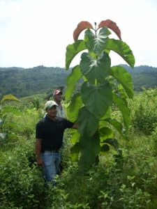
Vegetation type: Teak plantation
Monitoring:
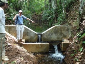
Hydrology: precipitation[rain gage with data logger], stream flow [level troll model 300; ISCO model 6712], well level [level troll model 300] and evapotransporation [ET gages model A] . In addition studies will be initiated to monitoring through fall, interception, and overland flow
Vegetation: growth performance of trees.
Soil: physical characteristics of soil in relation to soil hydrology.
Water chemistry: three broad types of water samples are collected: grab samples (stream water, throughfall, overland flow, groundwater), stream-water event samples, and wet-dry collector rainwater samples. Analysis of many dissolved and solid phases including bioactive, major, and trace constituents (PDF).